| 
             
              Image Number: 
             
           | 
          
             
              JRL18043959
             
           | 
        
| 
             
              Reference Number: 
             
           | 
          
             
              Map Collection (Flat) C17:70 Manchester (24)
             
           | 
        
| 
             
              Series Title: 
             
           | 
          
             
              Report on the Health of the City of Manchester, 1880
             
           | 
        
| 
             
              Parent Work Title: 
             
           | 
          
             
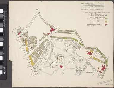
              Registration Sub-District. St. George's. Sanitary District No. 10
             
           | 
        
| 
             
              Alternative Parent Work Title: 
             
           | 
          
             
              St. George's
             
           | 
        
| 
             
              Creator: 
             
           | 
          
             
              Manchester (England) City Council
             
           | 
        
| 
             
              Creator Role: 
             
           | 
          
             
              Author
             
           | 
        
| 
             
              Creator: 
             
           | 
          
             
              Bastow, Richard Austin, 1839-1920
             
           | 
        
| 
             
              Creator Role: 
             
           | 
          
             
              Surveyor
             
           | 
        
| 
             
              Date Created: 
             
           | 
          
             
              1880
             
           | 
        
| 
             
              Publication Details: 
             
           | 
          
             
              Manchester: MCC
             
           | 
        
| 
             
              Scale: 
             
           | 
          
             
              71/2 inches = 1/4 of a mile
             
           | 
        
| 
             
              Language Code: 
             
           | 
          
             
              eng-GB
             
           | 
        
| 
             
              Language Name: 
             
           | 
          
             
              English
             
           | 
        
| 
             
              Subject: 
             
           | 
          
             
              Public health--England
             
           | 
        
| 
             
              Subject: 
             
           | 
          
             
              Sanitation--England
             
           | 
        
| 
             
              Subject: 
             
           | 
          
             
              Manchester (England)--Maps
             
           | 
        
| 
             
              Subject: 
             
           | 
          
             
              Manchester (England)--Buildings, structures, etc.--Maps
             
           | 
        
| 
             
              Category of Material: 
             
           | 
          
             
              Printed
             
           | 
        
| 
             
              Support: 
             
           | 
          
             
              Paper
             
           | 
        
| 
             
              Time Period Covered: 
             
           | 
          
             
              19th Century CE
             
           | 
        
| 
             
              Places Covered: 
             
           | 
          
             
              England: Greater Manchester: Manchester
             
           | 
        
| 
             
              Item Height: 
             
           | 
          
             
              350 mm
             
           | 
        
| 
             
              Item Width: 
             
           | 
          
             
              400 mm
             
           | 
        
| 
             
              Current Repository: 
             
           | 
          
             
              The University of Manchester Library, U.K.
             
           | 
        
| 
             
              Rights Holder - Image: 
             
           | 
          
             
              The University of Manchester Library
             
           | 
        
| 
             
              Rights holder - Work: 
             
           | 
          
             
              The University of Manchester Library
             
           | 
        
| 
             
              Access Rights: 
             
           | 
          
            ![]() This work is licensed under a Creative Commons Attribution-NonCommercial-ShareAlike 4.0 International License. Copyright of The University of Manchester  | 
        
| 
             
              Date Captured (yyyy-mm-dd): 
             
           | 
          
             
              2018-04-26
             
           | 
        
| 
             
              Image Creation Technique: 
             
           | 
          
             
              Digital capture by Heritage Imaging, The University of Manchester Library
             
           | 
        
| 
             
              Academic Project Lead: 
             
           | 
          
             
              Martin Dodge
             
           | 
        
| 
             
              Date Image Added (yyyy-mm): 
             
           | 
          
             
              2018-05
             
           | 
        
| 
             
              Educational Notes: 
             
           | 
          
             
              Project: Victorian Sanitary Survey Maps for central Manchester
             
           | 
        
| 
             
              Metadata Language: 
             
           | 
          
             
              eng-GB
             
           |